
Tutorial
Lesson 6
Using Maps
A map is a powerful way of describing a forthcoming extreme weather event. Maps can show the predicted track of an oncoming typhoon, or they can show predicted leels of storm surge flooding. However, there are some issues regarding the use of maps:
Agencies can assume that a map can contain and communicate all the relevant information.
In contrast, many people are not sure how to interpret the maps and, for some, maps are not understandable.
Maps are not the primary means of wayfinding for some people and communities.
In some cases, the meaning of the map needs to be put in the form of text, as well.

A good idea is to test how effective a map is, and whether or not people interpret is correctly. Take the figure below, which shows the trajectory of an oncoming typhoon. Imagine a survey respondent looking at the map for the first time and being asked questions such as:
Can you tell, from the map, when the typhoon will arrive at your town?
Why does the size of the area covered by the track increase as the storm moves onward?

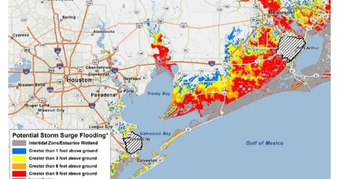
Similarly, consider a storm surge flooding map, such as shown below, and imagine the surve respondent being asked the following questions:
Can you find your place of residence on the map?
Can you judge what the predicted flood height will be for your area?
Given the previous storm surge track, by when do you think you should evacuate?
There are some problems with relying only on maps:
Some people may not understand their area in a map-like way. For example, some people figure out how to get from one part of town to another without imagining or using a map.
Other people may not be motivated or inclined to read and interpret a map and would rather read or hear direct information and advice.
As an example, in one survey, a sample of residents in a community were asked to study a print-out of a storm surge flood map and asked to locate their homes on the map and interpret how deep the predicted flood would be in their area. Only about 83% of them were able to indicate locations of their homes on the map (though not all did so accurately). Of those who indicated their homes on the map and provided their addresses, only 55% of those did so accurately.
This means that if the main mode of warning a population about an incoming cyclone and storm surge, you should translate the map into a message for that community, telling them when to expect the storm surge and what areas would be most affected. Instead of relying on maps alone, think of combining maps with words. The key is to write the message (and design the map) so that people will still get the information they need if the map is missing or the message is missing.